
Ice flow simulations that identify key data gaps

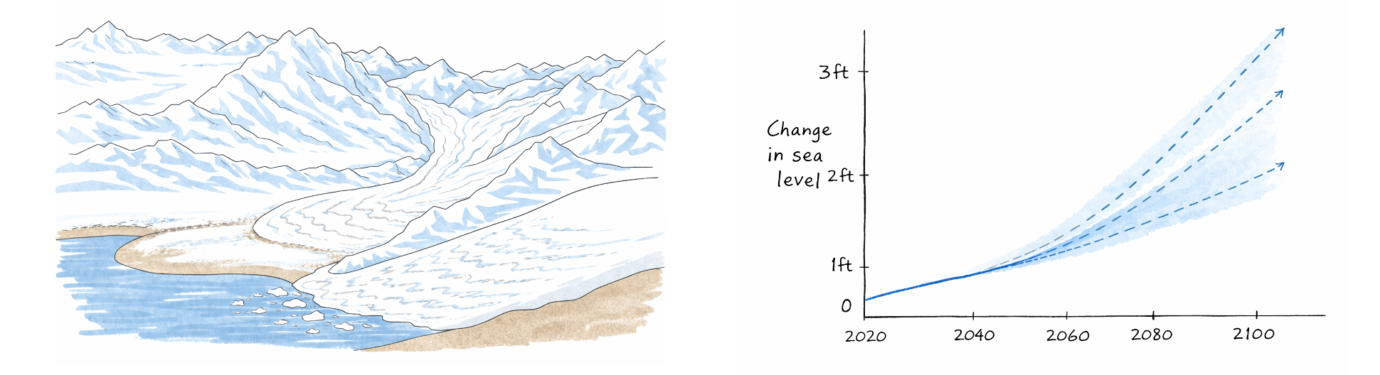
I use process based modeling to test how sensitive ice loss is to poorly observed englacial and subglacial conditions and to identify which measurements will most reduce projection uncertainty.
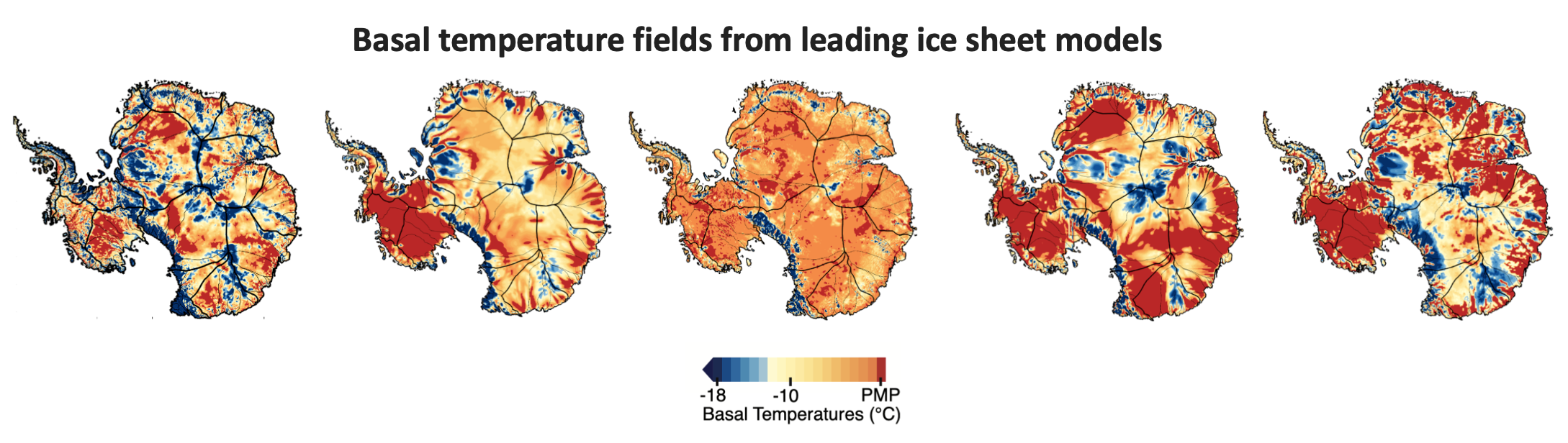
My research in Nature Communications used numerical modeling to show that small amounts of thawing at the base of the ice sheet in near melt regions could greatly reduce basal friction and increase ice discharge in parts of East Antarctica often treated as stable. This links basal thermal conditions to future ice loss vulnerability and identifies regions where observations are most needed. This is an important finding because leading ice sheet models used for future sea level rise projections have widely varying basal temperature fields. This implies that ice sheet model projections are not doing a good job of resolving the basal thermal state and therefore projections do not include ice loss related to basal thermal state mechanisms.
In the news
- Are we missing a crucial component of sea-level rise?
- Where Thick Ice Sheets in Antarctica Meet the Ground, Small Changes Could Have Big Consequences
Turning observations into model ready constraints
A key challenge in glaciology is converting geophysical observations into quantitative constraints that ice flow models can use, especially for basal and englacial conditions that are rarely measured directly. My approach is to focus on extracting more physical information about ice properties, including ice temperature and subglacial water, directly from geophysical datasets.
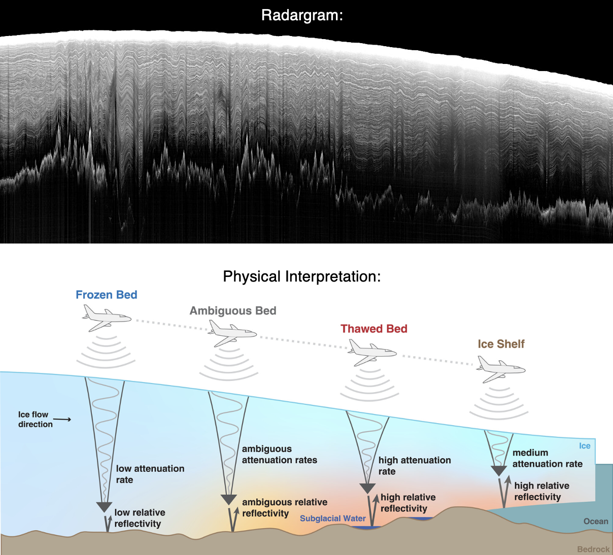
Fortunately there are extensive radar sounding datasets across the Antarctic and Greenland ice sheets and radar sounding data is sensitive to internal layering all the way to the base of the ice sheet, even in parts of Antarctica where there is ice over 4 km thick. I apply a range of methods, from geophysical to statistical and machine learning techniques, to extract more physical information from radar sounding datasets. Where there is no viable method, I design new methods to extract more from radar data, such as englacial attenuation and temperature using spectral analysis.
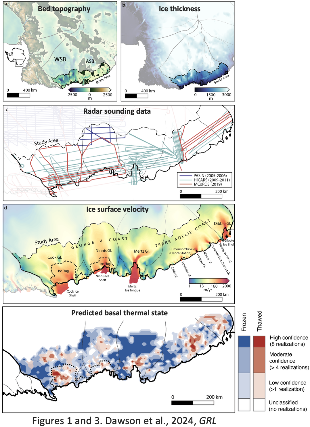
My work in Geophysical Research Letters classified frozen and thawed bed conditions beneath the outflow of Wilkes Subglacial Basin, producing a novel radar-derived thermal state assessment for a region central to East Antarctica stability.
In the news
Unlocking new ice sheet model capabilities
With better data products for englacial and subglacial conditions, this then poses the challenge of integrating this information directly into ice sheet models. Current ice sheet model data assimilation methods consist of using surface observations, such as surface velocity, to initialize ice sheet model simulations. My approach is to develop inversion and probabilistic frameworks that directly use subglacial geophysical measurements for model initialization. This could also include new parameterizations for better resolved subglacial feedback mechanisms.
Growing geophysical imaging demands
As ice sheet model geophysical integration capabilities increase, this will drive higher geophysical data demands. I believe the most promising approach is to combine existing large-scale radar sounding surveys, with new targeted field campaigns to fill in radar measurements and pair with other geophysical datasets, such as borehole observations, radiometers, and seismic imaging. This will ensure continuous estimates of subsurface properties in the most important regions for understanding ice sheet dynamics and potential contribution to sea level rise.
Informing and improving future projections
Refining projections within existing modeling frameworks versus asking whether key physics is missing can be viewed as competing priorities. I see their interplay as essential for advancing glaciological understanding, and I try pursue both by probing mechanisms such as basal thaw driven mass loss while developing geophysics based constraints that feed directly into model intercomparison and reduce uncertainty in projections.
Part of this is also recognizing that we are dealing with a complex system. Ice sheets are continually responding to both internal dynamics and external forcing, operating on a wide range of temporal and spatial timescales. I work with oceanographers and climate scientists to connect basal state and ice shelf melt to the ocean and atmospheric drivers that control heat transport towards Earth's ice sheet margins, using geophysical constraints to guide idealized and targeted modeling. This connects subsurface observations to both external and internal drivers, ultimately making future mass loss less nebulous and more grounded in observation and system scale understanding.
Multidisciplinary synthesis efforts
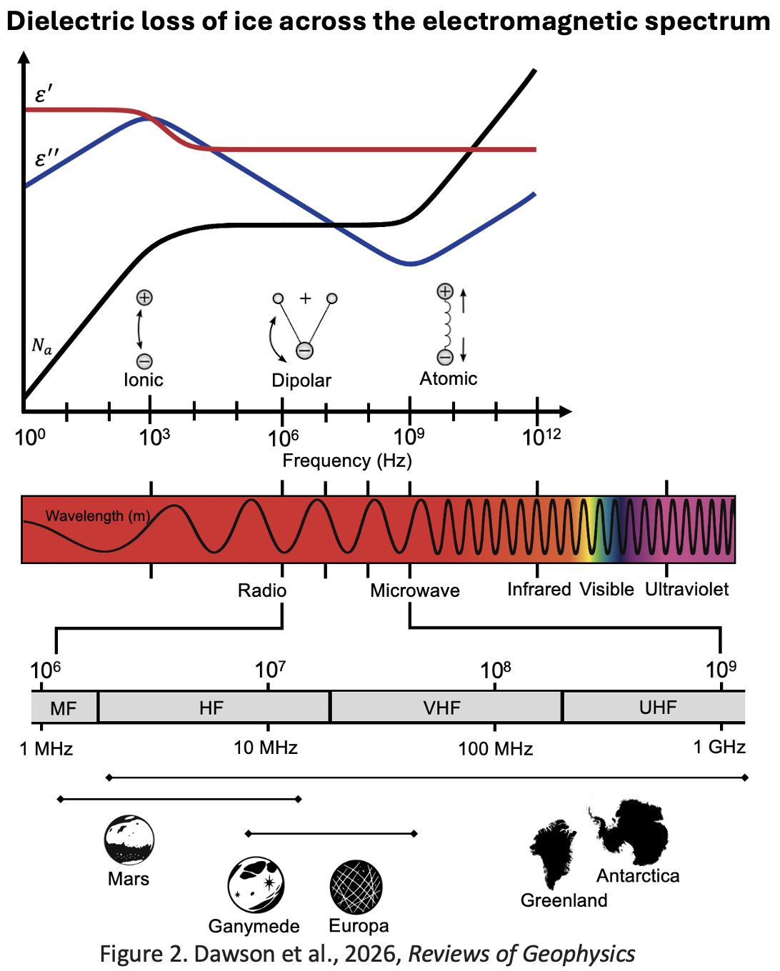
A central theme of my research is identifying physical commonalities that cut across disciplinary and observational boundaries. One example is my work synthesizing electromagnetic attenuation in ice, which draws together glaciology, geophysics, and planetary science within a shared physical framework.
In my Reviews of Geophysics article, I led a community wide synthesis of attenuation processes in ice, spanning intrinsic absorption, scattering, anisotropy, and frequency dependent behavior across radar systems used in Antarctica, Greenland, and icy planetary bodies. This work connects laboratory measurements, field observations, and theoretical models to clarify how temperature, chemistry, and ice fabric control radar signal loss. By placing diverse datasets and methodologies in a common context, the review resolves long standing inconsistencies between approaches and establishes clear pathways for translating radar observations into physical ice properties.
This synthesis directly informs my glaciological research by strengthening the physical basis for radar derived temperature and basal condition estimates, while also enabling knowledge transfer between Earth and planetary science communities facing similar observational challenges. More broadly, it reflects my approach to research, using synthesis not as an endpoint, but as a tool for identifying where new data, theory, and models can most effectively advance predictive understanding of ice sheet behavior.